Taming the Garmin Etrex 20/30:

Basic Setup (part 2)
Basic Setup (part 1) - System, Tones, Display and Tracks.Basic Setup (part 2) - Position Format, Heading, Altimeter, Fitness, Routing and Profiles.
Map Setup (part 3) - and some other Page Setups.
These notes and screenshots show a basic cyclists' setup for an Etrex 30 (and 20).
This is page 2 - follow this link for Etrex 20 & 30, Basic Setup (part 1)
The idea with most of this stuff is to SET IT, then FORGET IT.

All screenshots are Etrex 30 |
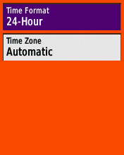
This is the 2nd page - or options 7-12 - of the Setup Menu as it appears by default. The Units and Time options are very straightforward. Unlike the older models, this Etrex automatically adjusts to time zones - much better!
Page Sequence is an interesting option but it brings us back to the important idea of re-arranging the tiles on the main menu screen, to make our own favourites more accessible. This is done (from the Main Menu) via the left or Menu key.
|
Your colourway may vary! |
|
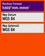
The Position Format menu has a vast array of choices, which might suit specialist purposes, but fortunately the default (see left) works well and is the best general-purpose catch-all option for anywhere in the world. Since I use my GPS about 50/50 in the UK and France, I leave it on this.
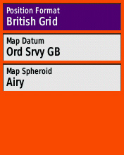
If you only cycle in the UK, you may well prefer to see OS Grid Refs rather than Latitude/Longitude in which case you'll want to set it up as in the right-hand screenshot. |
|
|
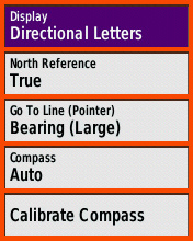
This is the Heading setup menu. (Some of this will be E30 only, not E20.)
None of this seems very critical to me. The compass doesn't have an 'Off' option (nor is there a separate manual switch as on the older Etrex Vista) so 'Auto' is definitely preferable from a battery-saving point of view.
Personally - as a road cyclist - I wouldn't bother with compass calibration, ever. It was within a few degrees, out of the box, and I've never noticed it being any worse than that. More than good enough given that I've opted for 'Directional Letters' - ie, only 8 compass points. | |
|
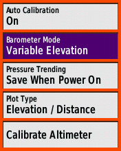
This is the Altimeter setup menu, only available on the E30.
Again, I would leave Auto Calibration on, and I wouldn't calibrate the Altimeter manually, ever. These options (see left) are the default and they work just fine. There is scope for further setup, on the main Elevation Plot page, which I might come back to later.
Note that in the E30, with the Altimeter on (as is the default), it is the Altimeter readings which are displayed in the 'Elevation' Data Field wherever that is used, and it is the Altimeter readings which are written into the Tracklog - NOT the raw GPS data.
| |
|
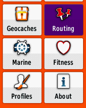
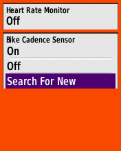
This is the 3nd page - or options 13-18 - of the Setup Menu as it appears by default. I haven't even looked at the Geocache and Marine options - I've just left them on the default settings. The Fitness option is where you can set up a Heart Rate Monitor and/or Cadence sensor (see right), of course you have to use Garmin's own accessories for this to work.
About just displays some information about the GPS and software version - there's nothing to do here. So on this page that just leaves Routing, which has a few important options (though not so many as on the older Etrex models). |
|
|
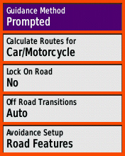
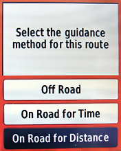
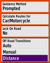
Here are the headline Routing options. I would strongly recommend using 'Prompted' Guidance Method, for maximum flexibility. This means that whenever you do a Where To?, you will get the prompt you see to the right here. If you choose one of the other options in this setup page, you don't get that prompt and so are locked out of the other two guidance methods. On a road bicycle, I would choose 'Car' as the best of the available vehicle types. 'Bicycle' will take you onto unwanted rough tracks more often than not. Lock On Road - doesn't really matter which option you choose here. 'Yes' corrects the GPS's calculated position to agree with the roads on the map. I have it turned off.
|
|
|
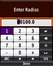
Off Road Transitions is the setting that determines when your GPS will prompt you (bleep) as you approach a waypoint. Generally 'Auto' is fine, it uses your closing speed and distance to generate a prompt a few seconds before the turn. But I find with the E30 that at slow speeds (walking, or cycling up hill maybe) the prompt comes too late, sometimes even on or after the turn. If you would like an earlier prompt, you can set it up here by opting for 'Distance', then choose your units (Yards or Metres is best) then entering a number. It's trial and error - I suggest 30 metres to start with.
|
|
|
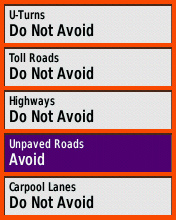
Avoidance Setup I suggest the settings here. It's important on a bike not to 'avoid' U-turns - they can sometimes save a cyclist a lot of leg-work! Nor can you 'avoid' Highways unfortunately - the category is far too broad and although there are many highways you would want to avoid, there are also some that are perfectly OK to cycle and may be necessary as part of a decent route.
| |
| Finally, Profiles Setup. Using this you can Create and Name new Profiles and delete or re-order existing ones. Creating a new Profile will save all your current settings into the profile you're currently using, and copy them to the new one, and switch you into that new Profile. As I mentioned earlier, I think it's a good idea to give each Profile a different colourway, so that you always know which you're in just from the screen appearance.
Although I very much like the idea of switchable User Profiles, I have to say I don't think they work very well in the E30. One problem is that if you make a temporary setup change - switching the map to North Up for example - that just gets written straight away to your current profile, essentially corrupting your finely-honed setup. For this reason I try to keep a 'master' profile which is well set up, then make a new one from that which is the one I normally use. If the setup gets too cockeyed I can recall my master Profile to restore my settings. Anyway, the final thing to do after all this setting-up is to connect to the PC again (Mass Storage Mode) and make a new backup of everything in the GPS memory - this is another way to keep all your setup work safe and retrievable. | ||
Francis Cooke
Some basic stuff:
Living with a Garmin: Etrex Basic Setup
Living with a Garmin: Battery Runtime and Etrex Jitter
Living with a Garmin: The Waypoints Limitation
Living with a Garmin: The Follow Road Trap
Living with a Garmin: The Circular Routes Problem
Living with a Garmin: Declutter the Page Sequence
Living with a Garmin: Living with Metroguide Maps
Living with a Garmin: Waypoint Naming (for direct-style routes)
Living with a Garmin: Colour your Tracks and Routes
Living with a Garmin: Create a Route on the GPS
Top 5 GPS Tips (pdf) reprint of Arrivee article published Feb 2007
Some GPS FAQs web version of Arrivee article published Nov 2008
NEW - Garmin Etrex 20/30 essays:
Etrex 30 review reprint of Arrivee article published Jan 2012
Etrex 20 & 30, Basic Setup
Taming the Etrex 20/30: Restore the 'Page' key.
Living with a Garmin: Show on Map (Tracks)
Dakota 20 review reprint of Arrivee article published Feb 2010
Living with a Garmin: Waypoint Naming and the Dakota 20 / Etrex 30
More Garmin essays - not-so-basic:
Garmin Etrex C Menu Map (pdf, July 2008)
Living with a Garmin: Full Reset
Living with a Garmin: Track, Route or Autoroute
Living with a Garmin: Three Ways to Beat the Waypoint Limit
Living with a Garmin: Three Ways to Beat the Trackpoint Limit
Living with a Garmin: Less is More
Living with a Garmin: Add Contours to your GPS Maps
Living with a Garmin: Struggling with GPX &... More GPX
Living with a Garmin: Screens you don't see every day
Living with a Garmin: Downgrade your Mapsource
Living with a Garmin: Put an OSM Map on your Garmin
Living with a Garmin: GPS Soak Test files to test your GPS waypoint capacity
OpenStreetMap and Mapsource Add OSM to your Mapsource collection
A Google Maps Workflow Create, Edit, Save, Share and Export a route