Living with a Garmin:

Waypoint Naming and the Dakota 20
This page also applies to the new Etrex 30. And maybe to other similar models.
Waypoint naming doesn't work as expected on the Dakota. Maybe it's a bug, maybe it's a feature.
Either way, this page shows how to work round it, or alternatively how to go with it and make it work for you.
|
Some people like to rename waypoints that are part of a Route, to embed turn hints.
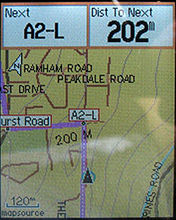
On the GPS you end up with a display something like this (this is an Etrex Legend Cx).
In Mapsource, it is easy to name Waypoints (provided they are proper User Waypoints, ie made with the waypoint tool) and all you have to do is make sure each one is uniquely named, and also try to stay within a limit of 6 characters (because more than 6 reduces the font size on the Etrex display).
| |
|
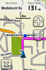
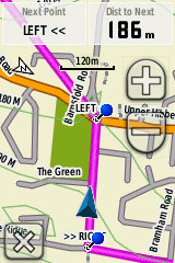
This screenshot is from my Dakota 20. The up-coming waypoint (the blue pin) has been named H02-R (to signify a right turn). As you can see, this waypoint name is not being displayed on the screen, anywhere.
It's the same on other displays (such as the Trip Computer page) - anywhere you can view the Data Field Next Point - this is what you get, not the Waypoint Name.
Maybe this is just a bug in what is still a fairly new GPS model from Garmin, in which case it may get fixed in some future software update (these are available at intervals, dowloadable from Garmin's website).
This display was the result of uploading the Route into the Dakota from Mapsource. Ie, connect the Dakota to the PC, in Mapsource use the Transfer menu to Send to Device. | |
|
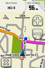
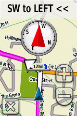
Here is the easy workaround NB the following short section applies to the Dakota, but not to the Etrex 30. It turns out that transferring the Route using a different method, making use of the Dakota's USB Storage Mode, it works much better and the same Route now appears as in this screenshot (left). The font is still somewhat small for my tired old eyes, but at least it's now working as it should!
So, instead of transferring from Mapsource, use Mapsource to save your Route as a .gpx file. | |
 |
An alternative is to make the new system work for you.
What is being displayed, in the first Dakota screenshot above, is actually the contents of the Waypoint Comment field - as opposed to the Waypoint Name field as expected.
Of course, for many people even editing waypoint names is too much faff. So an existing big project (up to 1000 Waypoints) could be adapted to work like this with the Dakota with only about 5 or 10 minutes' work. Not bad!
* Open your existing Route project in Mapsource, and in the left panel choose the Waypoints List, making sure that All Categories are being displayed. Use Transfer and Send to Device to upload to your Dakota, et voila.
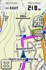
With the very latest Dakota software installed (as I write, v2.41 beta) you could get something like this rather nice combined Route, Map and Compass view (left).
Francis Cooke | |
Some basic stuff:
Living with a Garmin: Etrex Basic Setup
Living with a Garmin: Battery Runtime and Etrex Jitter
Living with a Garmin: The Waypoints Limitation
Living with a Garmin: The Follow Road Trap
Living with a Garmin: The Circular Routes Problem
Living with a Garmin: Declutter the Page Sequence
Living with a Garmin: Living with Metroguide Maps
Living with a Garmin: Waypoint Naming (for direct-style routes)
Living with a Garmin: Colour your Tracks and Routes
Living with a Garmin: Create a Route on the GPS
Top 5 GPS Tips (pdf) reprint of Arrivee article published Feb 2007
Some GPS FAQs web version of Arrivee article published Nov 2008
NEW - Garmin Etrex 20/30 essays:
Etrex 30 review reprint of Arrivee article published Jan 2012
Etrex 20 & 30, Basic Setup
Taming the Etrex 20/30: Restore the 'Page' key.
Dakota 20 review reprint of Arrivee article published Feb 2010
Living with a Garmin: Waypoint Naming and the Dakota 20 / Etrex 30
More Garmin essays - not-so-basic:
Garmin Etrex C Menu Map (pdf, July 2008)
Living with a Garmin: Full Reset
Living with a Garmin: Track, Route or Autoroute
Living with a Garmin: Three Ways to Beat the Waypoint Limit
Living with a Garmin: Three Ways to Beat the Trackpoint Limit
Living with a Garmin: Less is More
Living with a Garmin: Add Contours to your GPS Maps
Living with a Garmin: Struggling with GPX &... More GPX
Living with a Garmin: Screens you don't see every day
Living with a Garmin: Downgrade your Mapsource
Living with a Garmin: Put an OSM Map on your Garmin
Living with a Garmin: GPS Soak Test files to test your GPS waypoint capacity
OpenStreetMap and Mapsource Add OSM to your Mapsource collection
A Google Maps Workflow Create, Edit, Save, Share and Export a route