Living with a Garmin:

Add Contours to your GPS Maps
For many people, a map just isn't a map without contour lines.
|
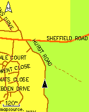
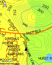
These pictures show a Garmin map before and after adding contours.
The GPS is an Etrex Legend Cx, This page is a 'how to' to get a similar effect on your GPS, using any street-style base mapping such as City or OSM. |
|
| Before going on - just to say there are other, easier, options. Garmin's Mapsource Topo maps have contours built in. However these maps, which have much better information about geographic features generally - lakes and rivers etc - are a bit less accurate than the street-style maps for road junctions. So if you are a cyclist operating mainly on-road, the street-style maps such as Metroguide or City are a better choice. Also Topo maps use a lot of storage and are quite expensive if you want to cover the whole country, whereas a single Metroguide install gives good coverage of most of Europe at a much lower price.
Another option would be to use an OpenStreetMap distribution with integrated contours (probably the contours would again be sourced from SMC, as in the screenshot above). One such is linked here, another linked here, but they are very big downloads. | ||
|
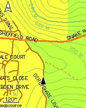
This picture shows the same set of contours, overlaid on OpenStreetMap for the same area (to simulate what an integrated distro mught look like). Notice that the OSM map is better in some ways (some tracks mapped towards the top of the screen, nicer styling of the main road) but less good in others (some small roads not mapped, National Park not shown properly). This is very typical of where the OSM project is at, in the UK, at this time (late 2009). It will only get better. In some other countries, it already is, much better than the 'establishment' maps. Follow this link to learn more about the OpenStreetMap project |
|
|
If you have a Colorado, Oregon or Dakota GPS, Garmin now do OS Maps for these units - but they are very expensive. It is also now possible to scan or draw your own maps (using a suitable non-copyright source) or use aerial photos, and get them to display as a base map on these new GPS types. This is quite new and people are still trying for the best workflow for this, and currently it's limited to small map areas. So all those are viable options, but what I'm going to describe is an inexpensive and flexible way of adding contours as an overlay, to any map. |
||
|
Sources for contour Maps: Covering the UK only, the Scottish Mountaineering Club offer a contours-only map (derived from NASA data) as a set of files downloadable here. These can be installed to appear as a separate mapset in Mapsource, and from there can be included in any mapset you load into your GPS. The installation process is not trivial, and a very good guide to the process is here. However, read on because I describe an alternative, and more flexible, installation method below. | ||
|
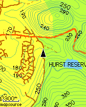
The SMC contours are spaced at 10 metre intervals (similar to OS 1:50,000 maps) and in some hilly places it can all get a bit busy on a tiny 2x1 screen. The installation process described above doesn't include any options for setting the colour, the contours just default to dark single-pixel lines which can get confused with minor roads (see left, NB all these screenshots are much more vivid than the actual GPS display). That is why I've opted to colour the contour lines (see right), to separate them out a bit from the roads and other features even in a zoomed-out view like this. |
|
|
Also, the SMC maps only cover the UK and Ireland. To get contours for Europe and many other parts of the world except North America, a good place to look is GPSMaps. These are not free (a full set for Europe costs about 120 euros), but it is possible to download limited sets as 'free samples' for your particular area of interest. These contours are spaced at 20m intervals, so for very hilly areas they could well be a better option than the SMC ones, even in the UK. Certainly in the Alps, the wider spacing is going to be more manageable. | ||
|
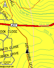
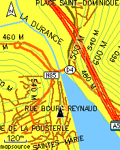
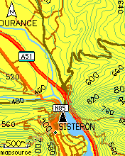
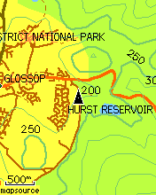
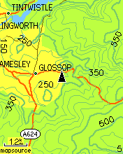
These pictures show a pinch-point on the Route Napoleon, in the Alps. Again the map is Mapsource Metroguide v9, with overlaid contours this time obtained from GPSMaps.de.
On the left is my usual 120m zoom level, on the right a much wider zoom that really shows off the contours and the dramatic terrain. |
|
|
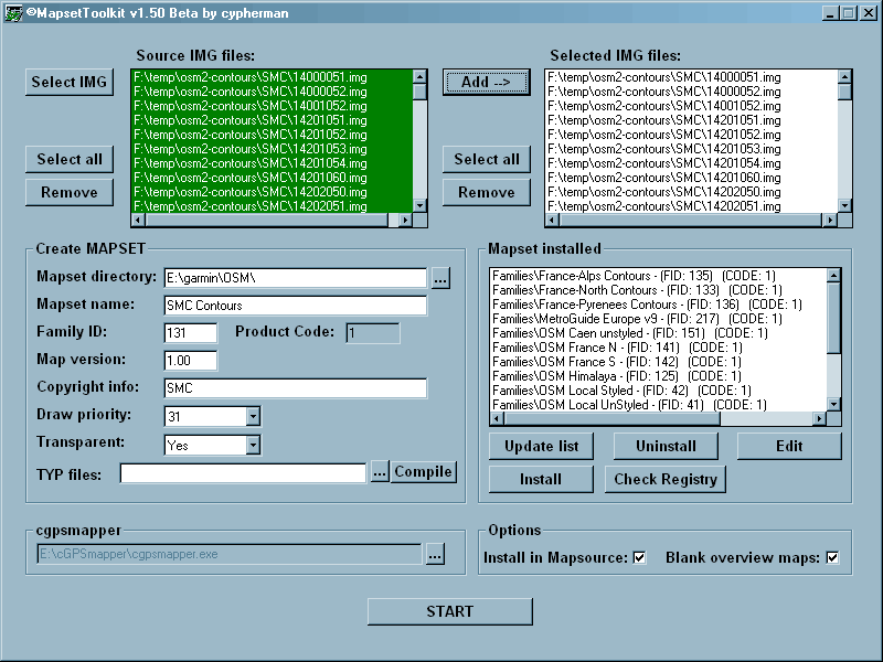
These GPSMaps 'tiles' - and any other .img tiles you may be able to obtain - require a different procedure to get them into Mapsource. However this procedure does allow the option of restyling and colouring the contour lines (you could even make them dotted if you want) - and it also can be used on the tiles downloaded from SMC and from other sources - in other words - this is a more generalised method for getting 3rd-party maps into Mapsource (and from there, onto the GPS), on a WinXP computer.
For this, you need two small and freely-downloadable programs.
Download your contours tiles, from SMC or GPSMaps.de, to a directory on your hard disk - they will all have 8.3 filenames such as 45623456.img, it is important to retain this precise filename structure and not to attempt to rename them in any way.
9. Click on START.
A successful job will end with the charming message Convert Termined
| ||
|
To colour the contours, or restyle them in any other way (dotted lines, maybe) you will need to do the process as above but specify a TYP file. I link a very simple one here 13100131.TYP right-click and Save As to download it.
This file just sets 6 types of contour lines (thin, medium and thick, land and sea) to mid-green. |
||
Francis Cooke
Some basic stuff:
Living with a Garmin: Etrex Basic Setup
Living with a Garmin: Battery Runtime and Etrex Jitter
Living with a Garmin: The Waypoints Limitation
Living with a Garmin: The Follow Road Trap
Living with a Garmin: The Circular Routes Problem
Living with a Garmin: Declutter the Page Sequence
Living with a Garmin: Living with Metroguide Maps
Living with a Garmin: Waypoint Naming (for direct-style routes)
Living with a Garmin: Colour your Tracks and Routes
Living with a Garmin: Create a Route on the GPS
Top 5 GPS Tips (pdf) reprint of Arrivee article published Feb 2007
Some GPS FAQs web version of Arrivee article published Nov 2008
NEW - Garmin Etrex 20/30 essays:
Etrex 30 review reprint of Arrivee article published Jan 2012
Etrex 20 & 30, Basic Setup
Taming the Etrex 20/30: Restore the 'Page' key.
Dakota 20 review reprint of Arrivee article published Feb 2010
Living with a Garmin: Waypoint Naming and the Dakota 20 / Etrex 30
More Garmin essays - not-so-basic:
Garmin Etrex C Menu Map (pdf, July 2008)
Living with a Garmin: Full Reset
Living with a Garmin: Track, Route or Autoroute
Living with a Garmin: Three Ways to Beat the Waypoint Limit
Living with a Garmin: Three Ways to Beat the Trackpoint Limit
Living with a Garmin: Less is More
Living with a Garmin: Add Contours to your GPS Maps
Living with a Garmin: Struggling with GPX &... More GPX
Living with a Garmin: Screens you don't see every day
Living with a Garmin: Downgrade your Mapsource
Living with a Garmin: Put an OSM Map on your Garmin
Living with a Garmin: GPS Soak Test files to test your GPS waypoint capacity
OpenStreetMap and Mapsource Add OSM to your Mapsource collection
A Google Maps Workflow Create, Edit, Save, Share and Export a route