A Google Maps Workflow:

Create, Edit, Save, Share and Export a Route (or Track)
|
Garmin's Mapsource software is expensive and not particularly user-friendly, and the most recent versions seem to have got worse rather than better. Although there is no real choice other than to use Mapsource maps in your Garmin GPS, when it comes to route planning on the PC there are plenty of options and some of the best ones are free.
Here I'll describe a workflow using Google Maps, which is steadily getting better and better.
All you'll need is a web browser such as IE, a text editor such as Notepad, and some upload software which would probably be your copy of Mapsource or Trip & Waypoint Manager that came with the GPS, but there are one or two other free options as well.
Some initial once-only preparation before we embark on a first route - see sidebar - * Organise your Favourites or Bookmarks by adding a new folder lets call it Routes. * Go to Google Maps http://maps.google.co.uk/maps?hl=en and bookmark it in your new folder. You may want to 'Set default location' while doing this, though its not essential. * Go to GMapToGPX http://www.elsewhere.org/journal/gmaptogpx/ and follow the instructions there to add the yellow-highlighted link to your new Favourites or Bookmarks folder. (This may generate a security warning - but its nothing to worry about.) * Go to TinyURL http://tinyurl.com/ and similarly add the link halfway down the page to your new Favourites folder. | |
|
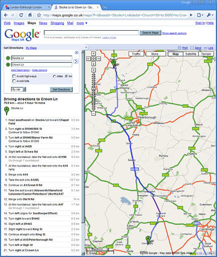
OK, that's all the prep - now let's map and save our first route, in Google Maps, and export it to GPS. My screenshots show as an example, leg 2 of LEL - that is, Gamlingay to Thurlby.
Open your browser and go to Google Maps. Zoom the map to a wide view of southern England, then double-click just slightly west of Cambridge, to centre the map there. Now in the form to the left, in the blank space marked B just type Thurlby and click Get Directions. You'll be offered a choice of three Thurlbys, choose Thurlby, Bourne. The map now updates to show you a route between the two places, highlighted in blue. (NB you could also have just scrolled the map and right-clicked on Thurlby and chosen 'Directions To Here' - just two ways to skin the cat.) Oh no! - it's going straight up the A1(M)!
|
|
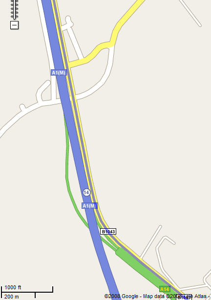
Time to click on Show Options - its near the 'Get Directions' button. Tick Avoid Highways and select km instead of miles. Click Get Directions again. The route alters a bit, around Peterborough - but it still seems to be going up the motorway, so what is going on here? Well if you zoom right in and look at the motorway section more closely, you'll find its actually now using the B1043, the Old North Road, which runs right alongside the main road for about 12km. It's even more obvious if you switch to the Satellite view.
Well, thats now a perfectly good 'cyclable' route but its still quite main-roady in parts and goes right through Peterborough - as cyclists we would want to find a better way.
Francis Cooke
|