Living with a Garmin:

OpenStreetMap and Mapsource
OpenStreetMap is a wiki-fied World Map - anyone can join the project and add to the map, filling in any features so far unmapped. Oh, and its free to access and to download.
Obviously this makes it very much a 'work-in-progress' and this will probably be obvious when you look at your own locality - typically the main roads and features are mapped but smaller roads may well be missing.
On the other hand, you may well find some cyclable tracks or cycle facilities on this map, that aren't on any of Garmin's Mapsource maps or even on Google Maps. There is even a special 'cycle map' view (click on the + ) which looks really good, with contours and shading added. Clearly there's a lot of love gone into this project.
Where it already scores heavily though, is in the remoter places of the world, where maps are poor or hard to find, and even the aerial photos in Google Maps aren't yet very high definition. Though it must be said that Google Maps is progressing mightily in these areas.
As of January 2009 -
(all these maps will be updated and improve, of course, making these pictures out of date, but they illustrate a point)
Garmin's best map (in Mapsource) of Kottayam, S.India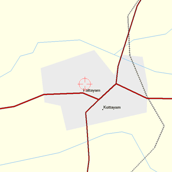
|
OpenStreetMap (in Mapsource) map of same area, same scale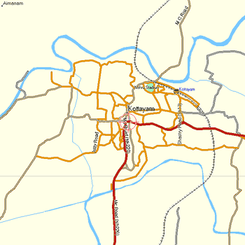
|
Google Map in web browser (slightly smaller scale)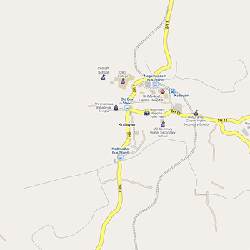
NB - all these pictures are reproduced at half size |
OpenStreetMap in web browser (similar scale)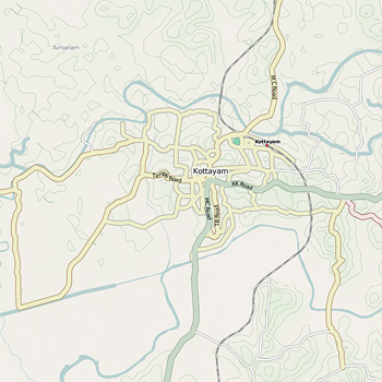
|
| Reminder - this comparison doesn't hold for places like UK and Europe, where (in January 2009) typically the pictures on the left above would be showing more detail than the ones on the right. | |
There may be many ways to skin this particular cat, but this is a very brief how-to for importing OpenStreetMaps into Mapsource, on a Win XP computer. The same procedure will work for other .img map tiles too, such as the contours tiles available from www.gpsmaps.de.
At minimum, you need two small and freely-downloadable programs, plus two URLs in your bookmarks.
The Programs are cGPSmapper and MapSetToolKit. Actually the latter is just a GUI front-end for the former, which does all the work.
http://cypherman1.googlepages.com/home is a good address to find both these downloads, along with lots of other very useful information. cGPSmapper is downloadable in several different versions - some of which are seriously expensive - but there is a freeware version which is OK for these purposes.
To install cGPSmapper run the downloaded file FreeSetup.exe - to install MapSetToolKit simply extract it from the .zip file, and create a shortcut to the extracted file MapSetToolKit.exe. (You don't need a shortcut to cGPSmapper, it just runs in the background when MSTK is run.)
(Update: I'm using MSTK v1.50, but I've had a few problems with a later download, v1.62 - in case you run into problems with the current download I include a link to the v1.5 zip here )
http://ulrichkuester.de/OSM/CoordinateToOSMTile.html is an address which displays the world map with an overlay of 'tiles' each of which is numbered. Use this to make a note of the tile numbers for the area you are interested in.
http://openstreetmap.teddynetz.de:81/latest/img/ is an address where you can download these map tiles. They are .img format files but are compressed in .gz format - so download the .gz files into a new directory and then extract the .img file from each one.
Create a new directory inside the directory where you have Mapsource installed, call it OSM.
That concludes the preparation.
Run MapSetToolKit. There is an excellent walk-through tutorial here:
http://sites.google.com/site/scdiscdi/mstk
I can't possibly improve on this, but ...
For now, disregard the section about the TYP file - the import process works OK without this, just don't fill in this line.
For OSM maps, try a Draw Priority of about 12. For contours overlays, use 31 and Transparency 'Yes'.
I found it essential to tick the box marked 'Blank Overview Maps' - unticked, my (old, slow) computer just freezes.
Otherwise, just do it like the tutorial, a successful job will end with the charming message Convert Termined
Open Mapsource and you'll find the new map listed in the drop-down.
It all works OK with the newest versions of Mapsource too (as I write, v6.15).
MSTK can also uninstall maps from Mapsource, so there's no harm in trying things out.
Once in Mapsource, these maps can be transferred to your GPS just like any other Mapsource map.
Styling a map, with the TYP file.
OK, I lied. Without the TYP file, everything works OK but the map in Mapsource is just a very stark-looking wireframe type of presentation. Personally I don't mind this, but some people might want something a bit more colourful, like the top-right of the four illustrations above (which is a screenshot of a styled OpenSourceMap in Mapsource v6.13.
Note that as of v6.14, Mapsource renders its maps much more prettily anyway, and even without a TYP file you'll get a fairly attractive map on screen. (However this comes at a price, see my comments on newer versions of Mapsource here.) But using the TYP file you will get at least some of the styling onto the GPS itself.
The extra bits and pieces you need are all accessible via the first address I gave above. Cypherman has generously made a sample file available here - this is a text file but MSTK will compile it into a TYP file. You could copy this text file and edit line 3 to match the Family ID you're going to use for your new map. Name the file with an 8.3 filename - what I do is, if the FID is to be, say, 121, I name the text file 12100121.txt.
Actually its not necessary for the FID in the TYP file to match the one you specify - MSTK can resolve the conflict without problems.
Then just use this file in your MSTK map-building process.
This sample file gives the styling shown above, in v6.13.
You can customise and make your own map styles using another download, GenTYP, or even just edit the text file to alter road colours and weights fairly easily.
Perhaps easier is to use this online TYP files editor - just upload a TYP file, edit/add/remove bits, and download it again.
Francis Cooke
Some basic stuff:
Living with a Garmin: Etrex Basic Setup
Living with a Garmin: Battery Runtime and Etrex Jitter
Living with a Garmin: The Waypoints Limitation
Living with a Garmin: The Follow Road Trap
Living with a Garmin: The Circular Routes Problem
Living with a Garmin: Declutter the Page Sequence
Living with a Garmin: Living with Metroguide Maps
Living with a Garmin: Waypoint Naming (for direct-style routes)
Living with a Garmin: Colour your Tracks and Routes
Living with a Garmin: Create a Route on the GPS
Top 5 GPS Tips (pdf) reprint of Arrivee article published Feb 2007
Some GPS FAQs web version of Arrivee article published Nov 2008
NEW - Garmin Etrex 20/30 essays:
Etrex 30 review reprint of Arrivee article published Jan 2012
Etrex 20 & 30, Basic Setup
Taming the Etrex 20/30: Restore the 'Page' key.
Dakota 20 review reprint of Arrivee article published Feb 2010
Living with a Garmin: Waypoint Naming and the Dakota 20 / Etrex 30
More Garmin essays - not-so-basic:
Garmin Etrex C Menu Map (pdf, July 2008)
Living with a Garmin: Full Reset
Living with a Garmin: Track, Route or Autoroute
Living with a Garmin: Three Ways to Beat the Waypoint Limit
Living with a Garmin: Three Ways to Beat the Trackpoint Limit
Living with a Garmin: Less is More
Living with a Garmin: Add Contours to your GPS Maps
Living with a Garmin: Struggling with GPX &... More GPX
Living with a Garmin: Screens you don't see every day
Living with a Garmin: Downgrade your Mapsource
Living with a Garmin: Put an OSM Map on your Garmin
Living with a Garmin: GPS Soak Test files to test your GPS waypoint capacity
OpenStreetMap and Mapsource Add OSM to your Mapsource collection
A Google Maps Workflow Create, Edit, Save, Share and Export a route