Living with a Garmin:

Colour your Tracks and Routes
Colouring a Track makes it much easier to follow.
|
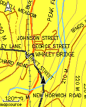
This picture shows a Track snaking its way through a town centre. The GPS is an Etrex Legend HCx, the map is Mapsource Metroguide v9, with overlaid contours (rather a lot of them, just here!) from SMC. This is how the Track displays by default - no colouring applied in Mapsource, and none in the GPS either. It's OK, but it's easy to do better. |
|
|
I like to colour uploaded Tracks bright green. This gives something much more akin to a traditional paper map that has been gone over with a highlighter pen. This colour is not much used for any map features on the Mapsource base maps, so the Track always stands out clearly.
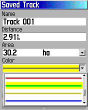
You can do this direct on the GPS (see right) - Or (easier) you can do the Track colouring in Mapsource before you upload it - its in the Track Properties. |
|
|
|
If you have several Tracks uploaded, you might want to use more than one colour - I sometimes use bright blue as an alternative colour, though I try to avoid it if possible because it could be confused with a motorway on the map. There is also the Active Track that the GPS lays down - I have this set up to cyan, which shows up well against either green or blue but it is the same as the map colour for water features. |
|
|
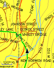
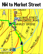
Many people like to use a Track in conjunction with Follow Road routing - the routing gives much better prompts and instructions than you can get from a Track alone, but Follow Road can occasionally lead you astray, especially if there is a set route to follow, as in a cycling event. This picture (left) illustrates just such a situation - the Track shows the 'correct' way to go (up a steep hill!!) but the autorouting is heading off up the main road. |
|
|
|
In newer versions of Mapsource, you can recolour Routes as well, using a similar method to colouring Tracks. Like the Tracks, one of the options is 'transparent'. However, in the Etrex C models this recolouring doesn't stick, on upload - all Routes end up the same old Magenta regardless of what colour is specified in the upload file. |
|
|
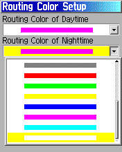
Only in the HC models, you can recolour the routing - this is a setup thing so changes the colour of any route you use, you still can't make separate Routes different colours in the way you can with Tracks - but you can only display one Route at a time anyway, so maybe that's not so important. And you don't have an option for 'transparent' unfortunately. Menu->Menu->Setup->Routing->Routing Color This colouring only really works for Follow Road routing - if you prefer Direct routes (as I do) you'll find that this isn't very useful to you. |
|
|
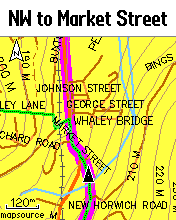
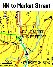
Most of the colours are not an improvement on the default magenta - red and blue for example, could just get confused with main roads. But how about white? (Since the map background is yellow.) I think this looks rather good (left) - when Route and Track are on-message you get a broad white stripe with a bright green line down the centre - very easy to follow.
Note that the Route draws over map backgrounds - such as forest or water - but under map features such as roads and road names. Note also that the Track always draws on top of the Route, and on top of any roads, but still under road names. It all works rather well. |
|
Francis Cooke
Some basic stuff:
Living with a Garmin: Etrex Basic Setup
Living with a Garmin: Battery Runtime and Etrex Jitter
Living with a Garmin: The Waypoints Limitation
Living with a Garmin: The Follow Road Trap
Living with a Garmin: The Circular Routes Problem
Living with a Garmin: Declutter the Page Sequence
Living with a Garmin: Living with Metroguide Maps
Living with a Garmin: Waypoint Naming (for direct-style routes)
Living with a Garmin: Colour your Tracks and Routes
Living with a Garmin: Create a Route on the GPS
Top 5 GPS Tips (pdf) reprint of Arrivee article published Feb 2007
Some GPS FAQs web version of Arrivee article published Nov 2008
NEW - Garmin Etrex 20/30 essays:
Etrex 30 review reprint of Arrivee article published Jan 2012
Etrex 20 & 30, Basic Setup
Taming the Etrex 20/30: Restore the 'Page' key.
Dakota 20 review reprint of Arrivee article published Feb 2010
Living with a Garmin: Waypoint Naming and the Dakota 20 / Etrex 30
More Garmin essays - not-so-basic:
Garmin Etrex C Menu Map (pdf, July 2008)
Living with a Garmin: Full Reset
Living with a Garmin: Track, Route or Autoroute
Living with a Garmin: Three Ways to Beat the Waypoint Limit
Living with a Garmin: Three Ways to Beat the Trackpoint Limit
Living with a Garmin: Less is More
Living with a Garmin: Add Contours to your GPS Maps
Living with a Garmin: Struggling with GPX &... More GPX
Living with a Garmin: Screens you don't see every day
Living with a Garmin: Downgrade your Mapsource
Living with a Garmin: Put an OSM Map on your Garmin
Living with a Garmin: GPS Soak Test files to test your GPS waypoint capacity
OpenStreetMap and Mapsource Add OSM to your Mapsource collection
A Google Maps Workflow Create, Edit, Save, Share and Export a route