Some GPS FAQs
This is a web version of the article printed in Arrivée 102, Autumn '08
It attempts to cover a lot of bases, but briefly - due to space restrictions on the printed page.
When reading, please keep the date of authoring - Summer 2008 - in mind.
|
Q: Is the Garmin Etrex Legend C still the best choice?
Well its not clear-cut but on balance and in a word, yes - that is, the current versions styled Legend HCx or Vista HCx still seem good to me. The Legend models have slightly better battery runtime and cost a little less, the Vista models add slightly better compass/altimeter and this interesting page, which might swing it for most people.
| |
| Garmin do have other interesting models - the GPSMap 60CSx is probably their best handheld model of all, but it works best when held vertically (like a walkie-talkie) whereas the Etrex series are optimal when horizontal (as on a handlebar mount). The latest Edge types are neatest of all on the bars, and are like cycle-super-computers combining heart-rate and cadence with GPS and fascinating 'virtual buddy' training. People who've got the Edge 705 really like it - but the limited runtime of the internal Li-ion rechargeable battery could be a problem - some people have even resorted to external power for these models. A new Garmin range called Oregon looks very interesting, however the large and beautiful touchscreen is very dim when viewed in daylight. Its only really usable with the backlight on, and that in turn means that battery runtime takes a big hit. The Oregon is the future, but it is expensive so because of that dim screen, you must try before you buy. All the Garmins are very weatherproof and there's a big user base if you need help or are sharing files or downloading routes from the Internet. To me that makes them the only option, but the maps (which cost extra) are an acquired taste and most people new to GPS would prefer to see OS maps on their screen. Several (non-Garmin) devices can do this, but the most practical one for cyclists seems to be the Satmap Active 10. Yet another option in the future, but not quite there yet, will be something like the iPhone combined with Google Maps, which is excellent. I might just add that the more basic, non-mapping GPS models are perfectly competent and accurate, but simply aren't recommendable to road cyclists at this stage of the game. | ||
 |
Q: What maps to use?
In Garmin GPS units there is no practical choice but to use their own Mapsource maps, which at first sight seem very crude compared with the OS maps we all know and love.
For road cycling use, the Topo maps are not as accurate as the City ones - for off-roaders, the reverse is true. | |
| Q: Etrex Jitter is my name for the problem of the handlebar-mounted GPS turning itself off suddenly, often on a bit of rough or grainy road surface. All the Garmin Etrex models are prone to this, especially as they get older. It’s not just the battery contacts, as you might expect, but another sprung contact inside the sealed body of the device that can break connection momentarily. Because the problem area is sealed inside a weatherproofed body, it's very difficult to fix. You could of course just send the unit back for repair, and Garmin UK do seem quite good at repairing/replacing stuff. Here though I give ways to reduce the vibration affecting the GPS. Firstly, stop the rattling between GPS and bar mount - as standard it is a slightly loose fit (though quite secure). Just build up the thickness of the shaped 'foot' on the Garmin backplate, using PVC tape. This means taping over the screw head (so make sure its really tight first) but be sure not to tape over the latch. I find 3 layers makes it a good tight fit. This little fix seems to improve things greatly. If you have normal thickness handlebars (not the newer oversize type) then a trick that helps a bit is to use the oversize version of Garmin's bar mount. The extra rubber needed to make this fit on ordinary bars absorbs a bit of the road shock - so don't screw it down any tighter than you have to. You can buy just the oversize clamp via Amazon.com for about a fiver. Chris Wilby has pointed out that there is an alternative to the Garmin mounting system, made by RAM it is a bulkier but very solid and secure 'Etrex Cradle' and 'Rail Mount'. These are available in the UK from GPS Warehouse www.gpsw.co.uk Is this a good moment to remind people to always use the lanyard - when fixing the GPS to the bike, just loop the lanyard round something to catch it if it ever springs off. Lithium cells help a bit with the vibration. A pair of Energizer Lithiums weighs 30g less than NiMH rechargeable. As a bonus they last a very long time too - would easily get you round a 600 without a battery change. Set the battery type to Alkaline when using Lithiums. | ||
|
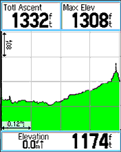
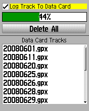
Q: Saved Tracks lose information. The GPS records a Track as you ride and this can be inspected later to re-live your ride on computer and show exactly where you've been. In times to come this could become another option to Brevet Cards and till receipts when validating AUK rides - especially Permanents. If you Save your track in the Garmin before downloading it, you'll find that useful information such as timestamps and altitude has been lost - it is now useless for validation purposes. In fact the saved tracks in the Etrex are limited to a maximum of 500 trackpoints each. In normal cycling use, 500 trackpoints represents around 30km, so if you Save any ride longer than that its going to get downsampled to fit the 500 points limit, and although the track still shows where you've been, you lose all that other vital information in the process. The way round this problem, if you have an 'x' model of GPS, that is, one with a data card, is to go into the Tracks menu and dig deeper still, through Setup to Data Card Setup, where you'll find a tickbox to Log Track To Data Card. With this, the GPS simply automatically records a 'track per day' onto the card, and these daily logs are not limited in any way - all the information is there. As you can see from the screenshot, the date of each file is embedded in its name. Out of the box, this logging option is not ticked, so you need to go in and enable it. (Note that on this page, Delete All will NOT delete your maps - only your tracks. Phew!)
Obviously you need to have a big enough card to hold all your maps and allow a bit of space for these tracks as well (they are very small files, compared with the map). I'd suggest a 1Gb or 2Gb card which costs less than Ł10 from places like 7DayShop. | |
 |
If you don't have a card-carrying GPS, then you need to download your Active Track as opposed to any of your saved tracks. The Active Track can have up to 10,000 points of full timestamped information - which is approximately 600km at the default 'auto' settings - but you'll need to set this up because out of the box it is set to only record about 3000 or so.- this is in Setup Map, Tracks, Track Points. Q: When Following a Route, the GPS doesn't behave. The problem here is largely down to poor documentation by Garmin, and poor choice of terminology, meaning that it's difficult sometimes to make the correct setup choices. | |
  | In particular, there's an option in the Setup Routing page for Guidance Method which many people have set to Follow Road, which on the face of it seems very reasonable. Follow Road is Garmin-speak for 'autorouting' and, especially in combination with another option on the same page, Off Route Recalculation set to Automatic - can potentially lead you right up the garden path. Please note I'm not at all against using Follow Road if that's what you choose to do - in some situations it works really well - but the problem is when its set up in the deep settings as the default behaviour, maybe because it was that way out of the box, but more likely simply because 'Follow Road' looked like the obvious and right choice, and the alternative, 'Off Road', looked wrong. If your GPS doesn't have autorouting maps on board - which it may well not have - then you must work in 'Off Road' mode - Garmin-speak for 'direct routes' - the GPS will default to that anyway but I've known people go into the settings and alter it back to Follow Road and then wonder why nothing works.
If your GPS does have autorouting capability and suitable maps installed - then I strongly recommend setting both Guidance Method to Prompted and Off Route Recalculation to either Prompted or Off. | |
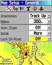 |
There is another confusing setting, 'Lock on Road' - this is found in the first page of Setup Map. If set to 'On' it won't really do much harm, until you take a short cut across country -
a bit of canal towpath maybe or an unpaved cut-through from one road to another. In those circumstances, the GPS will display an incorrect position on the map - it will show you as on the nearest road. If set to 'Off' you may see yourself apparently wandering off-road in areas of poor satellite reception. Personally I think this is the lesser of two evils, and this option is better set to 'Off'. Francis Cooke | |